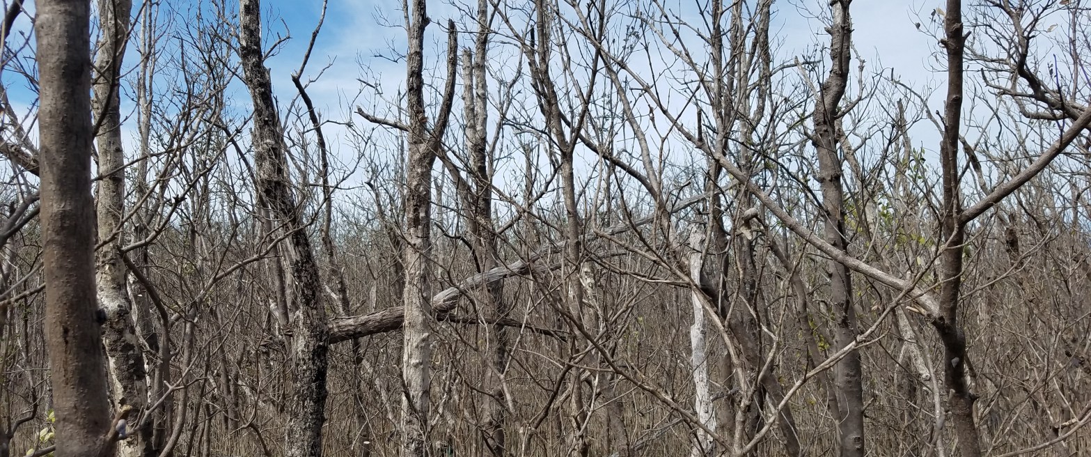
Hurricanes can drastically change the structure and composition of coastal ecosystems. Hurricane Irma, one of the strongest hurricanes ever recorded in the Atlantic, first made landfall in the Florida Keys archipelago before coming ashore in southwestern Florida near Everglades National Park (ENP) on September 9th and 10th of this year. Strong winds in excess of 225 km/h and a 3 m storm surge impacted a 100+ km stretch of the southern Florida Gulf Coast, resulting in extensive damages to coastal and inland ecosystems (Figure 1). Over the past 25 years, three other hurricanes greatly impacted ecosystems in ENP, but prior storms did not have a concentrated collection of coincident airborne lidar and optical remote sensing data.
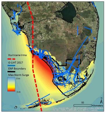
In response to the hurricane, we conducted a rapid response to collect repeat G-LiHT acquisitions over Southwest Florida to directly quantify ecosystem damages and coastal erosion from Hurricane Irma using pre and post-storm data. Rapid assessment of storm impacts was critical to characterize sedimentation, erosion, and changes in ecosystem structure and composition. In November of 2017, our team quickly mobilized to collect G-LiHT data in the beginning of December, nearly three months after Hurricane Irma. As a follow on to help calibrate and validate our airborne data, we also conducted a field campaign in January of 2018 to collect on the ground measurements across gradients of storm surge, wind speeds, and ecosystem damage.
The 2017 flights covered over 130,000 ha including areas of long-term monitoring sites with in situ measurements of vegetation, soil elevation, and hydrology to improve models of wetland vulnerability to saltwater intrusion and predict changes in future carbon stocks. The project, Hurricane Irma – Rapid Response (HI-RRes) with NASA G-LiHT will provide key datasets for local partners and collaborators to extrapolate information for strategic sites to areas not easily accessible in Southwest Florida. Our efforts will help to characterize the differential resilience of coastal vegetation directly after catastrophic storm events.
The combination of airborne and field campaigns served to address fundamental science and application needs arising from Hurricane Irma:
1) What was the extent of mangrove defoliation and mortality, coastal erosion and sedimentation caused by Hurricane Irma, and will this alter the resilience and vulnerability of the Florida Everglades and coastal wetlands in southern Florida to future storms?
2) Will disturbances in mangrove forests create a more favorable environment for invasive vegetation, and how will changes in topography and drainage ways affect regrowth and recovery?
DATA ANALYSIS & DISTRIBUTION
Level 3 G-LiHT lidar data products and fine-resolution imagery collected by G-LiHT in April and December of 2017 have been publically released for areas of southwest ENP at the G-LiHT webpage (https://gliht.gsfc.nasa.gov/). In select areas of ENP, Level 3 hyperspectral data products have also been made available. Forest structure data collected by the FCE LTER and FWC teams will be shared among the three groups and then publically available through the FCE LTER data portal (http://fcelter.fiu.edu/data/FCE/).
PRELIMINARY RESULTS
The first results of the airborne campaign were presented by David at the 2017 AGU Fall Meeting during the late-breaking disasters session (https://agu.confex.com/agu/fm17/meetingapp.cgi/Paper/332907).
- Goddard’s Lidar, Hyperspectral, and Thermal (G-LiHT) Airborne Imager collected data over 130,000 ha of coastal wetlands
- More than 1/5 of the mangrove canopy (foliage, branches, stems) at the mouth of the Shark River was lost to Hurricane Irma.
- Snapped branches or uprooted trees covered over 40% of the area mapped over Shark River
MAIN TAKEAWAYS
- Coastal disturbance legacies have the potential to influence the trajectory of mangrove resilience and vulnerability.
- Canopy structure can also change because of the influence of gaps created during natural disaster.s
- We are mapping fine scale canopy height structure to help improve storm surge models and provide predictions for future vulnerability and degradation.


